 Sunday, May 20, 2007
Changing Mountains
Location For The Night: Doc's Knob Shelter
Miles Walked Today: 22.60
Day Number:
35
I left camp this morning at 6:20. It was another perfect day, cool and clear, though not as cool as yesterday. There was a breeze out of the west all day.
These mountains are different than those I've walked through south of here. It's as if God grabbed the same mountains he made down in Georgia and North Carolina and stretched them out. The mountains themselves are not as steep and there are wider, flatter valleys, at higher elevations, leaving more room for farms and fields. Today's walk was in Jefferson National Forest, a considerable distance south of Mr. Jefferson's home at Monticello, but I can sure appreciate his and Mr. Washington's love of this beautiful rolling country.
I had a signal and posted yesterday's entry from the top of Brushy Mountain at 8:10am. In it I asked you to pray for my left leg. At the same time I received an email from J & M in Paducah saying they were praying for me, specifically my health. Big tears came to my eyes. I cannot tell you how much your prayers mean to me. And, they worked. My leg feels much better today. Thank you all so much.
At 10:10 I signed a register and saw that Flaxseed had signed in just two names above and it was dated today. I knew he was not too far ahead. Flax is a retired mechanic from Houston. He is 63 years old.
From about 10:30 to 1:30 I walked through a long flat area along the many tributaries of Dismal Creek. There were huge groves of large pines and tunnel after tunnel of rhododendron thickets. In these thickets there are no white blazes. It is reassuring when you finally exit one of these tunnels and find a tree with a white blaze on it.
I jumped a deer 10' from the trail at 2:55. She jumped away about 20' and stood and looked at me. Her coat looked scraggly as if she were not healthy.
There have been very few hikers on the trail the past three days. Lonely walking, but peaceful. Many are on there way back from Damascus.
There are pink azaleas up here too, to go along with the flame azaleas.
At 5:30 I caught up with old Flax. He had not gone back to Damascus for the shindig there after all. He kept on walking. It's taken me all week to catch him but now we are together again. It may be short lived though. I plan to walk the 9 miles into Pearisbug tomorrow and spend the night there. I need several real meals and both these PDA batteries need recharging bad. It takes 4 or 5 hours to recharge both of them. I plan to spend the night in a motel. I hope you enjoy me making sacrifices like this to post this journal via broadband every day. But, you never know, I may charge up and keep on walking.
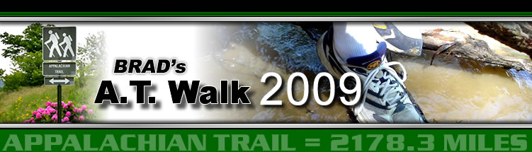
Today I started at Jenny Knob Shelter, mile 591.3, and ended at Doc's Knob Shelter, mile 613.9, a total of 22.6 miles. Today's photo is of Wapiti Shelter at mile 605.5. I ate lunch there today. God bless all of you and thank you for your prayers.
 Monday, May 21, 2007
Night Hikers
Location For The Night: Holiday
Miles Walked Today: 8.20
Day Number:
36
At midnight last night 6 hikers showed up at Doc's Knob. They had been hiking in the dark over a rocky trail. They were courteous and tried to be quiet, but quiet is relative when one must collect water, eat and set up camp, particularly in a place with no decent tent sites. As I left camp at 6:10 this morning their tents were set up on slopes I could never sleep on. It's a wonder they didn't slide off down the hill. This is not for me. I will walk in the daytime.
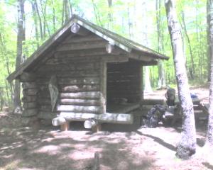
There were good views on top of Pearis Mountain this morning. Today's photo is a shot looking southeast (right) from the ridge we are walking. It gives you a good idea of the valleys and the farms.
I landed in Pearisburg, VA(elv. 1620'), at 10:20 this morning after a steep descent into town. As I descended the town sounds grew louder; cars and trucks, a train and its whistle, dogs barking, and lawn mowers, lots of lawn mowers.
The Rendezvous Motel had both my resupply and my bounce box, but no vacancy for tonight, so I got a room at the Holiday Motor Lodge. I had two good meals, went to the grocery, did my laundry, showered and shaved and visited with other hikers.
Today's short walk was from Doc's Knob Shelter, mile 613.9, to Pearisburg, VA, mile 622.1, on the banks of the New River, a total of only 8.2 miles for the day. Flaxseed, as usual, got groceries and hightailed it back to the trail. He came by the motel to make sure I knew he wasn't staying in town. The rascal. God bless all of you
 Tuesday, May 22, 2007
Lotta Walkin'
Location For The Night: Stealth site, approximately mile 650.1
Miles Walked Today: 28.00
Day Number:
37
I was up at 5:00am today, had a honey bun and a quart of orange juice in the room. Hardees was open and I got a sausage biscuit and a cup of coffee. I was walking at 5:40.
There is a big Celanese cigarette filter plant on the bank of the New River as you leave Pearisburg, its smokestacks fully ablast. Pearisburg is not a very pretty town. On the way out of town I saw a rabbit, the first one since I started.
Each time I leave one of these trail towns and climb back up into the mountains I feel invigorated. The sounds of town start dying away. The cool, crisp air replaces the hot, humid air of the valley. One can breath easier and perspiration evaporates faster.
At 10:23 I met a couple going south. They started at Harper's Ferry and are going to Springer, then up to Katahdin and south to Harper's Ferry. This is called a flip-flop and it is a legitimate way to hike the trail. They are Christians and some of their grandchildren are home schooled. Part of their home schooling is a project involving their grandparents' AT through hike. When I told them that one of my son's children are home schooled they said to Google "ODANDCC" to find out about this project. So, you home schoolers Google it. The man said he had experienced severe pain in his leg a couple of days ago. His wife prayed and it went away. He called it miraculous. I told him about my similar experience and the folks back home that are praying for me. I did not get their names but they are probably on the website.
One's senses become more keen as one walks alone in the woods. When you walk alone day after day for hours on end you hear, see and smell anything that is different than what you've been experiencing immediately.
Here is a big hello to Mr. Warmath's chemistry class at Paducah Tilghman High School. My son, Ben, who is in Nanjing, China, told me Mr. Warmath had you guys looking at my website for extra credit. I am using an alcohol stove. I guess that counts as part of a chemistry assignment.
At 3:51 there was a sign beside the trail saying "trail magic" with an arrow pointing to a creek. In the spring fed creek was a plastic laundry baskets full of cold soda pop. I had a big orange. Thanks trail angels.
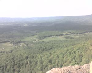
I caught Flaxseed at about 4:00 today. He and I are camped together tonight. Today I left Pearisburg,VA, mile 622.1, and walked a total of 28.0 miles arriving at a stealth campsite at mile 350.1 at 7:30 tonight. Today's photo is an alligator eating an orange. Strange what you see up here. I did not know alligators could climb this high.
 Wednesday, May 23, 2007
Short But Sweet
Location For The Night: Tarp near Sarver Hollow Shelter
Miles Walked Today: 15.90
Day Number:
38
Last night I slept better than I have on this entire trip. My alarm went off at 5:15 but Flax and I did not get up until 6:30. It was foggy and condensation was dripping from the trees. I left camp at 7:15.
This morning's walk featured sections in which all the mountain laurel is in full bloom. Pictures do not do them justice.
There are always rocks. Somedays there are more than others and in some places the rocks are bigger than others, but rocks are a daily part of the AT. Today they were average, we probably spent 50% of the time walking over rocks.
Walking the ridge is fun, especially when the hog's back is more like the back of a fat brood sow than a skinny razorback. Today we had some fun ridges. It would sure be nice if we had better views, but all these leaves keep getting in the way.
Bobby Darin's "Splish Splash" kept running through my mind today. I was singing as I walked:
"Splish splash, I was taking a bath, along about a Saturday night. Rub-dub I was washin' in the tub, thinking everything was alright. And then..., etc."
You over 60s that are reading this finish it for me.
At 2:18 I saw a chipmunk. There have been several bear sightings lately. Today, a girl hiker, Birdlegs (who has strong legs), saw one. I wish I could see one. We hang our food bags on a rope in trees at night to keep bears and animals out of them. The little animals are more of a problem than the bears.
At 2:44 I discovered that my umbrella was missing. I had left it a mile and a half behind at the place I stopped to eat lunch. I violated a cardinal backpacking rule, always look around for your stuff before you leave a place. Nothing to do but go back and retrieve it. Mark me down for three miles that don't count.
At 3:59 I saw the first red cedars I remember seeing up here. They were near a pasture south of VA42. At 4:00 some other hikers had left a watermelon and a cantaloupe on the trail with a trail magic note next to it. I ate a forth of the cantaloupe. I guess they had gone into Newport, VA, to buy it. Thanks guys.
When I told you a while back that these hills are not as steep as the ones back in Georgia and North Carolina I was talking about their appearance from the top looking down. Believe me, the climbs are still plenty steep.
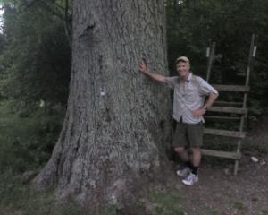
Well, it was a good day but short mileage. I started late and lost three miles time retrieving my umbrella. I started at mile 350.1, and ended near Sarver Hollow Shelter, mile 666.0, for a total of 15.9 miles today. Flax is here too. Today's photo is me beside an oak tree that could sure tell some tales if it could talk. That's a style to my left that we use to cross fences at pastures and such. God bless all of you.
 Thursday, May 24, 2007
Rock Climbing
Location For The Night: Stealth site (off trail) near VA624
Miles Walked Today: 22.60
Day Number:
39
Flaxseed and I walked out camp at 6:15 today. This was a perfect day; cool, clear and breezy. All the canopy is fully formed now, at all elevations, so there is plenty of shade. There are bugs under my tarp tonight after the light from this PDA, so this may be short.
I saw the first polk greens I've seen to date today. My mom loved polk. Some folks call it 'poke salit', but mom called it polk greens. She would ask dad to stop along the side of the road so she could pick it. She added bacon grease and cooked it down real good. I never did like it very much.
When you've been on top of the ridge, as we are everyday, and start descending it's comforting to here a stream gurgling down below as it means water is going to be available soon.
At 9:45 and for the next 45 minutes this morning I saw the most exquisite display of mountain laurel yet. We are going to continue to enjoy it and the rhododendron for good while as much has not bloomed yet. At 10:14 I saw a fuzzy mole. He was too quick for me to get a photo. At 11:58 I heard a bear. It was a bear for sure. It was off to the left about 20 yards on the downhill side of the mountain and it rustled and lumbered as it took off for about 5 seconds. Then it stopped. I walked 15 feet farther up the trail and saw its 'game trail' crossing the AT, a trail too heavy for deer. So, I threw a rock down the hill and it rustled and lumbered some more. I wish I could have seen him.
At 2:20 Flax and I met Joe and Judy McNamara and their children, John and Jennifer, at a the VA620 Trout Creek road crossing. They were there to meet their other son, Justin and his friend, Sarah, both through hikers. They had cookies, chips, and a cooler full of drinks that they offered to us. They were trail angels without even knowing it. Thanks Joe and Judy. God bless you.
From 5:00 until 6:00 this afternoon we were rock climbing as we descended down the north side of Cove Mountain. I put both pack straps on my shoulders at the same time for the first time in almost 700 miles so I could use my hands to climb. Rough going, but fun.
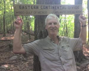
Today Flax and I walked 22.6 miles, from Sarver Hollow, mile 666.0, to VA624, mile 688.6. We arrived here at 6:20pm, got a lift to a convenience store, bought some groceries and ice cream, walked back up in the woods toward the trail, set up camp, ate our ice cream and then our big convenience store supper. We are full, happy campers tonight. Today's photo is yours truly at an 'Eastern Continental Divide' sign that notes the distance to the Atlantic Ocean and the Gulf of Mexico. Got to go. Bugs are bad. A few are down my shirt. Got to shake 'em out. God bless each and every one of you.
 Friday, May 25, 2007
Gator Hatchling
Location For The Night: Econolodge, Daleville, VA
Miles Walked Today: 25.70
Day Number:
40
Flaxseed and I left camp at 6:00 today knowing we were going to cover some ground. Our goal was town, a room, a shower, clean laundry, and food. We stopped in at the store where we bought last night's supper for a light breakfast. I had two ham and egg biscuits, a biscuit with sausage gravy, a Klondike ice cream bar, a big honey bun, a package of donuts a two cups of coffee. The longer you are out here the hungrier you are. Replacing all the calories you burn is nearly impossible. You cannot carry that much food weight, so town meals are important.
I've used three terms lately that may need some explanation. The first is 'tarp'. I camp under a simple homemade, rectangular tarp, not an enclosed tent, designed by Ray Jardine. The second is 'stealth'. I use this term for a campsite located in an area that is not generally used by campers. You simply select a suitable site in the woods and set up camp following 'leave no trace' rules for camping. The third is carrying my pack on 'one shoulder'. This is another of Ray Jardine's methods I have employed. I simply throw my pack up over one shoulder much like a high school student would a book bag. When that shoulder gets tired I switch to the other. I use my right shoulder about 75% of the time.
There were more squirrels and chipmunks moving around in the woods this morning than I've seen yet. They were everywhere. There is always something new and different. The glorious scent of new pine growth combined with the that of blackberry and honeysuckle blossoms is a testimony to God's wonderful creation.
Where are you Gimpy? If any one reading this knows a hiker trailnamed Gimpy, a RN from Fort Worth, please contact him and ask him to send Flaxseed and me his contact information via the 'contact us' page on this website. Flax and I think about him every day.
There have been questions from some of you about my physical and emotional well being. Both are good. Sore feet is about the physical complaint, but that's to be expected when you do 20 miles a day over rocks. Mentally, short of categorizing one who does this type of thing as nuts to begin with, I am fine. Flaxseed's companionship helps and I feel more confident everyday. I really believe I can finish this thing.
On today's walk McAfee Knob and the ensuing ridge (cliff) north of it offered spectacular views of the fertile valleys to west, and, on occasion, to the east. I believe this is a foretaste of what we will see in the upcoming Shenandoah region. The valleys are becoming wider with more row crops and broad, lush pasture fields.
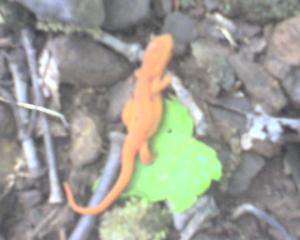
Today's photo is an orange alligator hatchling produced by that orange eating mama alligator. I didn't know alligators reproduced up this high. Did you?
Flax and I walked 25.7 miles today, starting at VA624 near VA311, mile 688.6, and ending here at US220 at Daleville, VA, mile 714.3. We arrived here tonight at 7:45, accomplished all I mentioned in the first paragraph including a huge meal at a Mexican restaurant and a pint of ice cream each. God bless you all.
 Saturday, May 26, 2007
Blue Ridge
Location For The Night: Stealth site on ridge, .2 mile north of Black Horse Gap
Miles Walked Today: 13.80
Day Number:
41
After a good night's sleep at the motel I was up at 6:00 for the continental breakfast. I had 8 donuts, four or five small cups of orange juice and a cup of coffee. Flax followed suit about a half hour later. This was Flaxseed's first night in a motel since he started at Springer on April 18, two days after I started, so it was a real treat for him. After the motel breakfast I came back to the room and wrote yesterday's report while eating a pint of cherry-vanilla ice cream. We both made some phone calls.
I had received a drop box here at the motel. We took our time packing and checked out at about 9:30 while eating more motel pastries. The time spent resting was good - therapeutic.
We walked a half a mile to a Kroger's, bought some groceries, checked out an outfitter store, talked to some other hikers and ran into Buttercup's Mom, the trail name of a through hiker's mom. Her real name is Joyce and she had flown in to visit her daughter, Buttercup, for Memorial Day weekend. She works for the Girl Scouts in Wichita, Kansas. She was kind enough to drive Flax and me to a CVS Pharmacy a couple of miles away so Flax could buy a new knee brace and ankle brace. Then she took us back to the trailhead. Thanks Buttecup's Mom. You were a real trail angel to us.
We were walking again at 11:32. Most of the north bound hikers that we meet along the trail now started hiking around the middle of March instead of the middle of April. This is because Flax and I are averaging more miles per day than most hikers out here. We are able to do this because we spend more time walking each day, not because we walk that much faster. I get a great deal of personal satisfaction out of walking, even walking long hours. It's what we're out here for, so why not be up and at it? It's fun to see the miles click by, enjoy everything the trail has to offer along the way, and chalk up both as a good experience at the end of a challenging day.
At 5:00pm we stopped at Wilson Shelter Creek to cook and eat. I cooked, Flax eats all his food cold. While there we met Birdman, a mild mannered ornithologist from Bangor, ME, that knows his birds. After supper we kept on walking.
At 6:48 we reached the Blue Ridge Parkway at Black Horse Gap. This has got to be some kind of a milestone as the Blue Ridge Parkway is famous. Trail magic greeted us there; a cooler of drinks, snacks, and miscellaneous hiker supplies. Thanks trail angels.
Today we walked from US220 near Daleville, VA, mile 714.3, to .2 mile north of Black Horse Gap, mile 728.1, a total of 13.8 miles for the afternoon. Today's photo was taken yesterday. It shows some of the fertile, wide valleys to the west that I mentioned yesterday. God bless all of you.
 Sunday, May 27, 2007
Hot Today
Location For The Night: Stealth site, top of Floyd Mountain, elv. 3560'
Miles Walked Today: 22.40
Day Number:
42
We were up and going today at 6:00am, but we walked south for awhile, back to the cooler full of treats that we passed last night. We both had a coke, a snack cake and an apple. Flax took a coke for the road too.
This morning's walk was easy. We walked along the Blue Ridge staying near the Parkway which we crossed 5 times at scenic viewpoints where they have parking areas and information boards. But this afternoon was a different story. It was hot and we had some tough climbs. This last one from Hamps Branch, elv. 1250', up to the top of Floyd Mountain, elv. 3560', was a dilly. We were both very hot and tired so we stopped early today, about 5:45. That gives me a chance to write this while it's still daylight with no pesky night bugs bothering me. It's 8:07 right now.
At 12:51 today Flax and I saw a mother (hen) turkey off to the left on the downhill side of the trail. She did not make a beeline to get away as the others have in the past. Instead she shuttled off as if trying to get us to follow her. She crossed the trail about 50 yards in front of us and circled back toward us on the uphill side of the trail, all the time well within sight. She was making the sound the turkey hunters make with the wooden box call when they lightly scrape a stick overit. She circled all the way around and back over to the downhill side of the trail trying to lead us away from the place we saw her first. We figured she was protecting her young, but we never did see any of them. It was exciting and interesting for us.
At 4:45 we met some Scouts and leaders from Troop 94, Yorktown, VA. They were headed south to spend the night at Bryant Ridge Shelter
It's hazy here. My son, Gil, told me that it's hazy in western Kentucky too. He said it was caused by the wild fires in Florida and Georgia. I wonder if that's what's causing it to be hazy here? We don't get much news up here and we didn't turn the TV on in Daleville.
Well, we had plans for a big day today but the heat and the climbs had other ideas. We walked from a campsite .2 mile north of Black Horse Gap, mile 728.1, to the top of Floyd Mountain, mile 750.5, a total of 22.4 miles for the day. We chose to stop here for another reason too. It's much cooler up here than it is in the low spots and there's a good breeze up here.
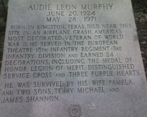
Today's photo was shot on top of a mountain about a week ago. It's a picture of the inscription on a plain stone memorial honoring Audie Murphy, the World War II hero, who died in a plane crash near the mountain top. The words on the memorial speak for themselves. I posted it tonight in honor of Memorial Day tomorrow. God bless you all and God bless all the service men and women, decorated or not, that have fought to protect our freedom.
 Monday, May 28, 2007
A Bear - Finally
Location For The Night: Stealth site beside Johns Creek
Miles Walked Today: 22.00
Day Number:
43
We left camp at 6:00am today. I was in the lead descending the north side of Floyd Mountain. At 6:07 I heard a loud rustling about 50 feet off the trail on the downhill side (left). The rustling stopped and so did I. Then I saw him, a little bear, probably no more than 150 pounds, down the mountain about 75 feet. It was just a brief glimpse, no more than two seconds, but it was a real live bear. What I remember most is his coat. It was coal black and it had a sheen to it similar to the sheen that a healthy dog's coat would have.
The mountain laurel and rhododendron tunnels, or thickets, I told you about several times are in full bloom now. I saw quite a few pink azaleas today too.
There are a lot of chameleons up here now, literally, not figuratively.
We need some rain. It is bone dry here.
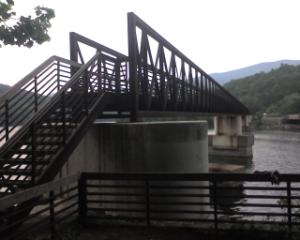
At 2:45 I saw the James River for the first time from high upon the mountain. This far upstream it is a swift running river with some rapids. As I descended it grew closer. Finally, at 4:55 I crossed it on a relatively new footbridge (photo) built for the AT in 2000.
This morning at about 10:00 we were at elevation 4225' on the top of Apple Orchard Mountain. This afternoon when we crossed the James River we were at 710'. Quite a drop in elevation.
Today we started at the top of Floyd Mountain, mile 750.5, and tonight we are camped beside Johns Creek, mile 772.5, a total of 22.0 miles for the day. Flax, as you may have guessed is here too. God bless everyone of you.
 Tuesday, May 29, 2007
Above the Clouds
Location For The Night: Budget Inn, Buena Vista, VA
Miles Walked Today: 20.30
Day Number:
44
Last night I was lulled to sleep by the long continuous call of a whippoorwill. At first light this morning I was greeted by the call of a bob-white quail. What a life.
Flaxseed and I were walking today at 5:45. At 6:10 I stopped at John's Creek Shelter to visit the facility out back. Two people were asleep in a tent. These were the only two people we saw all day. I don't know where all the hikers are. We figure we're between large groups both in front and behind.
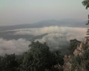
At 7:00 on top of Fuller's Rocks, elv. 2470', we were looking down on the clouds, not mist or haze, clouds (photo). Pretty neat.
At 9:37 on top of Bluff Mountain I saw a good size whitetail buck with antlers in velvet. He looked like he had at least 8 points. He stood and looked at me from 30' away but before I could get the camera ready he had eased off into the woods. Then, at 9:49, I saw him again. This time he took off running down the trail.
At 10:51 I crossed the Blue Ridge Parkway again. This was about the seventh or eighth time the trail has crossed it. It is tempting to walk along it instead of climbing up and down all these mountains.
This afternoon there were many streams along the trail. This is because we were not on the ridge, but descending to a lower elevation. Water sources are scarce on the ridges, but plentiful at lower elevations.
At 3:22 an animal about the size of a groundhog with a long bushy tail dropped down out of the bottom of a tree 10' in front of me. It had a squat, heavy body and short legs, built low to the ground. It may have been a badger or a woodchuck. I'm not sure. It's not something you see in western Kentucky. It scurried down the hill and out of sight.
The beauty of God's creation
Is all around us up here. If I don't report it often enough don't think I am taking it for granted. And, 3 years ago today God brought forth on this earth my granddaughter, Summer Charis Arterburn. I don't take her for granted either. I love her with all my heart. I miss her terribly. Happy birthday Summer. I love you.
We're at a motel tonight. We have an excuse though - out of food. A man's got to eat. We did our laundry too. And best of all, we met F.W. And Brenda, a generous young couple that volunteered to take us to a restaurant and to the Wal-Mart in Lexington, VA, where we resupplied. Thanks guys. You are truly trail angels.
Today we left John's Creek, mile 772.5, and ended up here at a pretty raunchy motel on US60 in Buena Vista, VA, mile 792.8, a total of 20.3 miles for the day.
|